Ashbury Map Textile Hanging
Funding

This project has been funded by Vale of the White Horse District Council 'Percent for Art' scheme, whereby large scale development projects pay a percentage to fund Public Art. Ashbury are using this fund to create of a textile map stitched by as many members of the village as possible which will be hung in the village hall. It is expected that the map will be completed in the first quarter 2015 to coincide with the completion of the refurbishment of the hall.
Initial Design
The initial map was made by local artist Stuart Roper who drew a layout of the village and photographed local houses which he integrated into the design. This was printed full size so that the design could easily be transfered onto fabric. Other events such as the annual nativity play, local characters - the postman of course, and flora and fauna of the area have also been included. The finished quilt which will be made into a textile quilt about 5' x 5'
Inspiration

One of the inspirations for the map came from a piece that was created by the community in Wanborough, and completed in 1994 which is shown left and some details below. This map and hangs in the Parish church and we were kindly shown the map by Barbara Parnell, one of the designers and main inspirations of the map. She gave a wonderful insight into the ethos behind the map, as many people to take part with whatever skills they had and no piece turned away. This is exactly the plan for the Ashbury map, everyone is welcome and nothing will be refused!
Another map, completed in 2000, hangs in nearby Liddington village hall. Again, I was lucky enough that one of the designers, Kay Archer showed me the Liddington map. A detail is shown below right, on this map many of the houses are represented by their names or addresses. Also included are patches, buttons, beads and bells, a really eclectic mix of materials.


Materials

The timing of the project was perfect! After agreeing the size and design outline of the map it was time to bite the bullet and purchase the materials and where better to go than the Festival of Quilts in Birmingham.
Armed with a credit card, Margaret Smith, the village coordinator and project manager, and I set off to buy the quilting materials, fabric paints, aida and tapestry canvas, image transfer paper wool, embroidery threads and numberous other requirements for the quilt - these are just some of the materials we returned with!
Kickoff 16th August 2014
The design and techniques used for stitching each item on the textile was to be up to the person stitching it and we used Stuart's photographs as placemarkers for the size and location of the subject. Some of the houses were just too big to fit into the allocated space so some people planned to do a representional piece or just a section of the frontage. Paper prints of the photographs were distributed at the kickoff meeting together with any particular materials that had been requested. Where people had selected to make a cross stitch of their house, I prepared some charts to use as a starting point.


Workshop 3rd September 2014
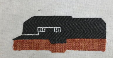
This was the first workshop I had attended after we had distributed the materials and the first piece was already finished! The war memorial in the centre of the village was embroidered with stranded and metallic thread onto a stone coloured felt. Other pieces shown that are in progress are two of the houses, the design for the allotment, which will have a background fabric printed with a bee design to represent the hives, and painted on a transparent fabric laid on top will be images of some of the fruit and vegetables grown there. Also shown are the phone box library and a design of one of the local horses.


Workshop 24th September 2014
This was a machine embroidery workshop where we covered stitching with the feed dog up and the feed dog down. Machine embroidery will be used specifically for the borders which will surround the map and document everyone who took part.
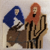
More pieces that were still in progress were also brought to the meeting. Shown here is an embroidery of Holly Cottage, represented by the porch and what will be some holly bushes, the annual nativity play in tapestry and the Ash Tree, using appliqued felt and embroidery which is the symbol of the Cricket Club, the bat, ball and stumps are still to be added.
We also did some more work on the background of the map, the knitted roads are nearly all ready and were pinned in position. It is shown here alongside Stuart's printed map which we are using to get the dimensions correct this will enable all the individual pieces to drop into their allocated place.


Workshop 10th October 2014
This was a dropin workshop for general advice, stitching, a show and tell and a coffee. Many pieces are now finished and all in such completely different styles, but there is also still plenty of work in progress both in Ashbury and on pieces that have been taken to Luxemburg, Italy and Portugal!
Below are some of the flowers and animals from around the village as well as the pond, one cyclist to represent the many that regularly ride through and a child made as a tiny wire model, the first of many that will represent the children that walk up the road to the creche ...


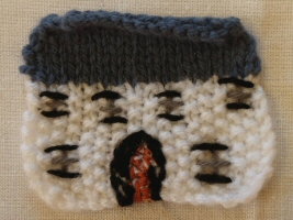
... and some of the houses, farms and cottages. The cameo head has been made to represent Thomas Stock's cottage, he established the first Sunday School in the United Kingdom.


Workshop 6th December 2014

This was the last workshop, and the main aim was to involve the village children in making trees to place around the village houses. As well as tiny woolen pompoms, they made tree trunks from French knitting and painted pelmet vilene in different shapes.
Of course more finished pieces arrived and we played with positioning them on the finished background.


February, 2014

The pieces for the map are, if not complete, almost there and all the names are in of the people that have contributed, either with photographic images which have been transfered to fabric, or with the stitching and making up. 136 pieces in total and 96 contributers.
I am going to make the borders for the map and machine embroider the title and names of each of these contributers onto bands of cream cotton.

Mounting the Frame, 15th April 2015
The frame that was built to house the map is nearly 6'x 6'and made from pale oak with 5mm thick toughened glass. We were grateful that local architect Roger Baker had checked the walls would actually be able to support the considerable weight!
Once the wooden frame surround had been attached to the wall, the map was lifted into place. We had designed the hanging system so that a rod was passed through two separate sleeves on the back of the map and then inserted into three cups. In this way the rods would not show, and the panel would appear, suspended in the middle of the frame. Once this was in place, the glass cover could be inserted.
As you can see it took several men, several hours, not to mention several journeys back to their workshop before the operation was complete!


Unveiling Ceremony, 18th April 2015

The map was finally unveiled at the opening of the newly refurbished village hall and over 200 residents of Ashbury and the surrounding villages attended, together with the chairman of The Vale of the White Horse District Council, and Abi Brown the Arts Development Officer from the council, who had provided the funding for the map, via money from Redcliffe Homes.
Margaret Smith, the coordinator, had put together a booklet with images of all the pieces from the map, together with an explanation of why individuals had chosen that particular image which was available to buy and the remaining materials were sold off to raise funds for further refubishment of the village hall.
I think it was fair to say that this was a truely worthwhile use of the Redcliffe Homes money and the village now has a work that is not only valued by the community but has brought residents together in a way not possible with other 'Percent for Art' projects.
Below is a picture of Abi, Stuart, Margaret and I at the unveiling, together with the sections of the map which show the four villages.


 Return to Projects